Mt Rainier: Summit Climb via DC (August 98)
        Amar Andalkar's Ski Mountaineering and Climbing Site
Home | Ski Mountaineering | Photos & Trip Reports | Equipment & Info | Cascade Volcanoes | Ring of Fire | Site Map
Trip Introduction | Previous Page | Next Page

View of Mt Rainier from Paradise
A Sea of Clouds below Camp Muir
Camp Muir Pinnacle
Looking Up at Gibraltar Rock
The Climbing Route to Cathedral Gap
Dawn in the Summit Crater
View Across the Summit Crater
Liberty Cap from the Crater Rim
Looking Down on Grand Park
The Final Steps to the Summit
Self-Portrait on the Summit
View of St Helens from the Summit
View of the Crater from the Summit
Descending the Upper Ingraham Glacier
Overhanging Serac
Panorama of the Ingraham Glacier
Traversing Below the Cleaver
Crevasse on the Ingraham Glacier
Camp Muir from Cathedral Gap
The Three Summits of Mt Rainier
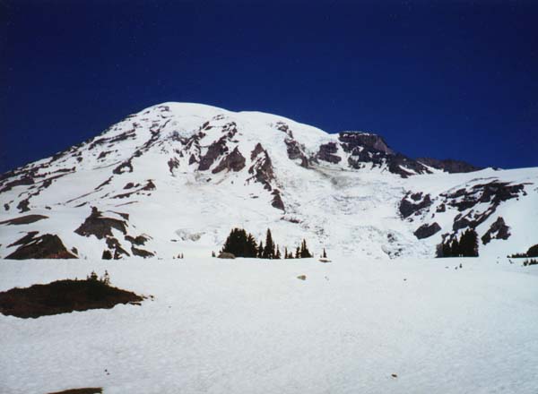
This photo shows Mount Rainier looking north from 6000 ft, a mile beyond the Paradise visitor center. The first half of the climbing route follows the Muir Snowfield along the ridge at right to Camp Muir (10080 ft), located below Gibraltar Rock, the large outcropping at the right edge of the summit dome. At the time of this trip, the upper half of the route went up Disappointment Cleaver (hidden by Gibraltar Rock), then traversed left roughly along the skyline and ascended the summit dome to the crater rim.
(Since our climb began at night; this photo is one taken on 6/28/98.)
Trip Introduction | Previous Page | Next Page
Home | Ski Mountaineering | Photos & Trip Reports | Equipment & Info | Cascade Volcanoes | Ring of Fire | Site Map
Amar Andalkar <andalkar@u.washington.edu>