 | Aerial view of Langjokull from the north (photo by Oddur Sigurdsson) <click to enlarge> |
Langjökull
4462 ft (1360 m) . |
||
| Location: | Western Iceland, 50 miles (80 km) NE of Reykjavik | ||
| Lat / Long: | 64.8° N, 20.0° W | ||
| Volcanic Type: | Stratovolcano (subglacial) | ||
| Volcanic Status: | Dormant, last eruption about 925 AD | ||
| First Ascent: | |||
| First Ski Descent: | |||
| Skiable Vertical: | up to 3000 ft (900 m) | ||
| Langjokull volcano underlies the northeast end of the large icefield of the same name, the second largest (370 sq. miles / 950 sq. km) of the four major icefields in Iceland. The terrain is the most moderate (i.e. flat) of any of the Icelandic volcanoes included in this section, and there is a large caldera hidden deep beneath the ice. This used to be a very popular area for skiers, but has become increasingly overrun by jeeps and snowmobiles. Standard routes onto to icefield are from the western and eastern ends, and traversing the 30 mile (50 km) length takes several days on skis. | |||
 |
More photos and info about routes, access, etc. may be added in the future ... |
||
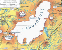
| Topographic map of Langjokull (1:750,000 scale) <click to enlarge> |
|||