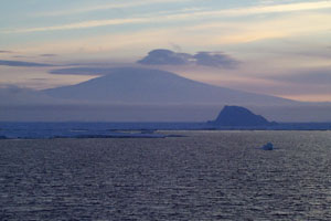
 | Mount Siple from off the coast of Siple Island (photographer unknown) <click to enlarge> |
Mount Siple
10203 ft (3110 m) . |
||
| Location: | Siple Island at the northern edge of Marie Byrd Land, Antarctica | ||
| Lat / Long: | 73.4° S, 126.7° W | ||
| Volcanic Type: | Shield volcano | ||
| Volcanic Status: | Dormant (possibly active?) | ||
| First Ascent: | |||
| First Ski Descent: | |||
| Skiable Vertical: | over 10000 ft (3000 m) | ||
| Mount Siple is an enormous shield volcano which forms the bulk of Siple Island on the coast of Antarctica, rising directly from the water's edge to a height of over 10000 ft (3000 m) and comparable in volume to Mount Erebus at roughly 450 cubic miles (1800 cu km). This is a youthful volcano by Antarctic standards, formed within the past 2 million years and with satellite cones less than 100,000 years old along its edge. Unlike the other inland volcanoes of Marie Byrd Land, Mount Siple's bulk is not concealed by the West Antarctic Ice Sheet, which only has a thickness of about 600 feet (200 m) at its terminus here along the coast. Surprisingly, Siple has received even less visits and less study than the other remote volcanoes of this region (none of which have been visited much). In fact, it is the only one of these volcanoes which does not even have a published topographic map, the only available map being a rough sketch map (see below). Antarctic cruises along the coast do occasionally pass within sight of Mount Siple, assuming the weather is clear enough to actually see it. | |||
 |
Some useful links: Global Volcanism Program: Mount Siple United States Antarctic Resource Center USGS Atlas of Antarctic Research (online maps & photos) |
||
| Shaded relief map of Mount Siple (1:500,000 scale) from USGS Sketch Map Hobbs Coast - Marie Byrd Land <click to enlarge> |
|||
More photos and info about routes, access, etc. may be added in the future ... |
|||