 | Korovin from the south near Atka village (photo by James Dickson) <click to enlarge> |
Korovin Volcano
5030 ft (1533 m) . |
||
| Location: | Northern end of Atka Island in the Aleutian Islands, Alaska | ||
| Lat / Long: | 52.4° N, 174.2° W | ||
| Volcanic Type: | Stratovolcano | ||
| Volcanic Status: | Active, last eruption 1998 | ||
| First Ascent: | |||
| First Ski Descent: | |||
| Skiable Vertical: | over 5000 ft (1500 m) | ||
| Administration: | Alaska Maritime National Wildlife Refuge | ||
| Korovin Volcano is situated on the northern tip of Atka Island, on the northern rim of the ice-filled and heavily glaciated Atka Caldera. Several other prominent volcanic cones ring the caldera, including Kliuchef and Sarichef, and all three of these have had historical eruptions, with Korovin the most active. Atka Island has a native village at Nazan Bay, south of the caldera, with a harbor and landing strip with occasional service from Dutch Harbor (Unalaska). Thus access to Atka Island is much easier than most of the outer Aleutians, although any visit requires permission from the native village. | |||
 |
Some useful links: Global Volcanism Program: Korovin Alaska Volcano Observatory Alaska Maritime National Wildlife Refuge |
||
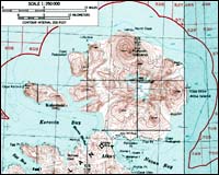
| Topographic map of Korovin and Atka Caldera (1:250,000 scale) from USGS Atka and Seguam <click to enlarge> |
|||
More photos and info about routes, access, etc. may be added in the future ... |
|||