 | Closeup view of Hvannadalshnukur, the highest peak of Oraefajokull, from the east (photo by Hjalmar Bardarson) <click to enlarge> |
Öræfajökull
6952 ft (2119 m) Highest point in Iceland . |
||||||
| Major Peaks: |
| ||||||
| Location: | Southeast Iceland, southern edge of Vatnajokull, 50 miles (80 km) SW of Hofn | ||||||
| Lat / Long: | 64.0° N, 16.7° W | ||||||
| Volcanic Type: | Stratovolcano with caldera | ||||||
| Volcanic Status: | Active, last eruption 1728 | ||||||
| First Ascent: | Oraefajokull massif: Svein Palsson, 1794 Hvannadalshnukur: Frederick W. W. Howell, Pall Jonsson, and Thorlakur Thorlaksson, 1891 | ||||||
| First Ski Descent: | |||||||
| Skiable Vertical: | over 6500 ft (2000 m) | ||||||
|
Oraefajokull is the highest and largest volcano in Iceland, and also one of the most spectacular. A
broad squat cone topped by a flat 3 mile (5 km) diameter ice-filled summit caldera, its volume of about
90 cubic miles (370 cubic km) compares favorably with much taller stratovolcanoes such as California's
Mount Shasta. Located directly beside the
Atlantic Ocean, it juts out as a peninsula from the southern end of the Vatnajokull icefield, and
magnificent outlet glaciers spill in all directions from its summit caldera. Like several other of the
more accessible Icelandic volcanoes, its climbing history dates back over two centuries and it remains
one of the most popular areas for climbing and ski mountaineering. Access to Oraefajokull is
exceptionally easy from roads to the south, and it provides a standard starting point for a traverse of
Vatnajokull. |
|||
 | Topographic map of Oraefajokull (1:100,000 scale) <click to enlarge> |
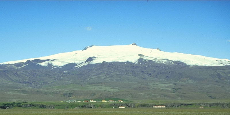 | View of Oraefajokull form the south near the coastal highway <click to enlarge> |
||
| More photos and info about routes, access, etc. may be added in the future ... | |||