Skiing the Pacific Ring of Fire and Beyond
        Amar Andalkar's Ski Mountaineering and Climbing Site
Ski Mountaineering Photos & Trip Reports Equipment & Info Cascade Volcanoes Ring of Fire Site Map

North America | South America | Asia | Oceania & Antarctica | Beyond the Ring | Volcanic Seven Summits | Volcano WebCams
NORTHERN ANDES MAP
  Pico Bolivar
  Pico Cristóbal Colón
  Nevado del Ruiz
  Nevado de Santa Isabel
  Nevado del Tolima
  Nevado del Huila
  Cotacachi
  Cayambe
  Antisana
  Sincholagua
  Cotopaxi
  Illiniza
  Carihuairazo
  Chimborazo
  Tungurahua
  El Altar (Capac Urcu)
  El Sangay


CENTRAL ANDES MAP


SOUTHERN ANDES MAP


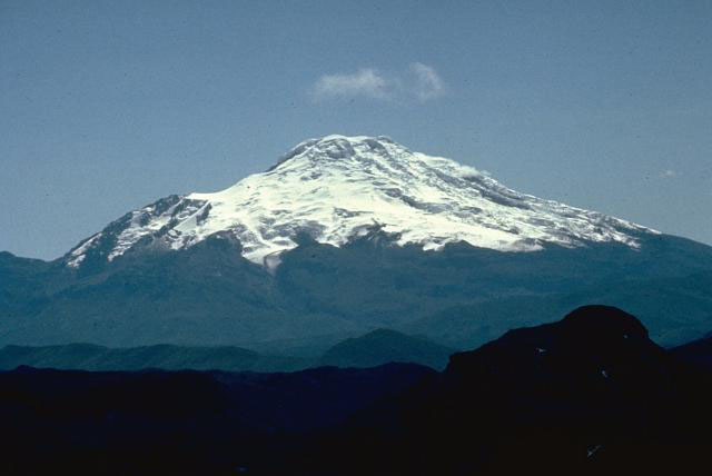
| Cayambe seen from the southwest
(photo by Minard Hall)   <click to enlarge>

Cayambe
    18997 ft (5790 m)     Highest point on the equator .
Location: Cordillera Real, N Ecuador,
35 miles (55 km) E of Quito
Lat / Long: 0.0° N, 78.0° W
Volcanic Type: Stratovolcano
Volcanic Status: Dormant
First Ascent: Edward Whymper & party, 1880
First Ski Descent:
Skiable Vertical: ?


A brief description of Cayambe will be added here soon, along with a topographic map.
More photos and info about routes, access, etc. may be added in the future ...


Previous Page (Cotacachi) | Cayambe | Next Page (Antisana)
North America | South America | Asia | Oceania & Antarctica | Beyond the Ring | Volcanic Seven Summits | Volcano WebCams
Ski Mountaineering Photos & Trip Reports Equipment & Info Cascade Volcanoes Ring of Fire Site Map

Amar Andalkar   Seattle, WA, USA   <About the Author / Contact Me>
All material on this website is ©1997-2024 by Amar Andalkar unless otherwise noted.
Page content last modified: Monday, January 5, 2004
PHP script last modified: Tuesday, February 4, 2020