Mount Shasta Region, I-5 and US 97 Corridors North of Shasta
|
Mount Shasta SnowCam, city of Mount Shasta,
east of I-5 @ MP 738, looking NE at Shasta
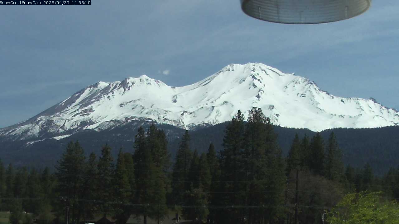
Elevation: 3500 ft
|
Grass Lake Cam, on US 97, 15 miles N of Mt Shasta,
PRESET 3 looking south has a view of Shasta

Elevation: 5104 ft
|
Mount Hebron Cam, on US 97,
25 miles NNE of Mt Shasta

Elevation: 4260 ft
|
Dorris Hill Cam, on US 97 near Oregon border,
42 miles NNE of Mt Shasta

Elevation: 4354 ft
|
Lava Beds National Monument, 40 miles NE of Mt Shasta,
looking N across flanks of Medicine Lake Volcano

Elevation: 4800 ft
|
SR 139, 1/2 mile south of Perez Inspection Station,
53 miles ENE of Mt Shasta, 20 miles E of Medicine Lake

Elevation: 4462 ft
|
Distant view of Shasta & Medicine Lake Volcano (far left)
from 60 miles NNE on hillside above Klamath Falls, OR

Elevation: 4700 ft
|
ShastaCam, city of Mt Shasta,
east of I-5 @ MP 738, looking NE at Shasta
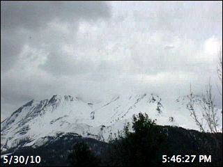
Elevation: 3500 ft
|
Weed Elementary School, east of I-5 @ MP 747,
10 miles west of Mt Shasta, looking at Shastina

Elevation: 3550 ft
|
Anderson Grade Cam, west side of SB I-5 @ MP 780,
34 miles NW of Mt Shasta

Elevation: 2963 ft
|
Central Yreka Cam, east side of I-5 @ MP 775,
32 miles NW of Mt Shasta

Elevation: 2674 ft
|
South Yreka Cam, west side of I-5 @ MP 772,
30 miles NW of Mt Shasta

Elevation: 2753 ft
|
Weed Airport Cam, east side of I-5 @ MP 753,
on Shasta landslide deposit, 14 miles WNW of summit

Elevation: 2936 ft
|
Shasta River Bridge Cam, I-5 @ MP 750,
on flanks of Mt Shasta, 12 miles west of summit

Elevation: 2905 ft
|
North Weed Cam, I-5 @ MP 749,
on flanks of Mt Shasta, 11 miles west of summit

Elevation: 3461 ft
|
I-5/US97 Cam, in Weed on I-5 @ MP 747,
on flanks of Mt Shasta, 10 miles west of summit

Elevation: 3646 ft
|
South Weed Cam, east side of NB I-5 @ MP 746,
on flanks of Mt Shasta, 10 miles west of summit

Elevation: 3646 ft
|
Summit Drive Cam, west side of I-5 @ MP 743,
on flanks of Mt Shasta, 10 miles west of summit

Elevation: 3840 ft
|
Black Butte Summit Cam, west side of I-5 @ MP 742,
on flanks of Mt Shasta, 9 miles WSW of summit

Elevation: 3912 ft
|
Abrams Lake Cam, east side of I-5 overpass @ MP 741,
on flanks of Mt Shasta, 9 miles WSW of summit

Elevation: 3861 ft
|
I-5/SR89 Interchange Cam, west side of SB I-5 @ MP 736,
on flanks of Mt Shasta, 10 miles SW of summit

Elevation: 3528 ft
|
Mt Shasta Ski Park, north of SR 89, looking north from base,
partial view of Mt Shasta from 6 miles south of summit

Elevation: 5500 ft
|
Mt Shasta Ski Park, north of SR 89,
looking at terrain park

Elevation: 6000? ft
|
Mt Shasta Ski Park, north of SR 89, looking north
from Douglas Butte towards Coyote Butte and Mt Shasta

Elevation: 6600 ft
|
Snowman Hill Cam, east of McCloud Summit on SR 89,
on flanks of Mt Shasta, 10 miles south of summit

Elevation: 4498 ft
|
I-5 Corridor South of Shasta, Sacramento River Canyon and Shasta Lake
|
Mott Road Cam, in median of I-5 @ MP 734,
on flanks of Mt Shasta, 11 miles SSW of summit

Elevation: 3185 ft
|
Central Dunsmuir Cam, west side of I-5 @ MP 730,
14 miles SSW of Mt Shasta

Elevation: 2420 ft
|
Sims Road Cam, on I-5 @ MP 718,
24 miles SSW of Mt Shasta

Elevation: 1735 ft
|
Gibson Cam, on I-5 @ MP 714,
38 miles SSW of Mt Shasta

Elevation: 1666 ft
|
Pollard Flat Cam, on I-5 @ MP 712,
30 miles SSW of Mt Shasta

Elevation: 1506 ft
|
Lamoine Cam, west side of SB I-5 @ MP 710,
32 miles SSW of Mt Shasta

Elevation: 1405 ft
|
Vollmers Cam, east side of I-5 @ MP 707,
34 miles SSW of Mt Shasta

Elevation: 1223 ft
|
Lakehead Cam, in median of I-5 @ MP 704,
36 miles SSW of Mt Shasta

Elevation: 1160 ft
|
Antlers Bridge Cam, west side of I-5 @ MP 702,
37 miles SSW of Mt Shasta

Elevation: 1020 ft
|
Sacramento Hill Cam, east side of NB I-5 @ MP 700,
38 miles SSW of Mt Shasta

Elevation: 1433 ft
|
Salt Creek Cam, on SB I-5 @ MP 698,
39 miles SSW of Mt Shasta

Elevation: 1218 ft
|
OBrien Cam, west side of SB I-5 @ MP 695,
42 miles SSW of Mt Shasta

Elevation: 1388 ft
|
Sidehill Cam, on SB I-5 @ MP 693,
44 miles SSW of Mt Shasta

Elevation: 1575 ft
|
Pit River Bridge, east side of NB I-5 @ MP 691,
45 miles SSW of Mt Shasta

Elevation: 1025 ft
|
Fawndale Cam, west side of I-5 @ MP 689,
47 miles SSW of Mt Shasta

Elevation: 1010 ft
|
Bass Mountain Cam, 2.5 miles W of I-5 @ MP 689,
48 miles SSW of Mt Shasta

Elevation: 2775 ft
|
Pine Grove Cam, west side of I-5 @ MP 684
in Shasta Lake, 52 miles SSW of Mt Shasta

Elevation: 749 ft
|
I-5/SR 44 Cam, west side of I-5 @ MP 678
in Redding, 58 miles south of Mt Shasta,
PRESET 1 looking north has a distant view of Shasta

Elevation: 599 ft
|
Woodside Meadows Rd, just SE of I-5 / SR 44 junction
in Redding, partial view of Mt Shasta from 58 miles south

Elevation: 600 ft
|
Hartnell Cam, west side of I-5 @ MP 677
in Redding, 59 miles south of Mt Shasta,
PRESET 1 looking north has a distant view of Shasta

Elevation: 550 ft
|
South Bonnyview Cam, west side of I-5 @ MP 675
in Redding, 61 miles south of Mt Shasta

Elevation: 567 ft
|
Riverside Road Cam, west side of I-5 @ MP 670
in Anderson, 65 miles south of Mt Shasta

Elevation: 461 ft
|
Deschutes Road Cam, west side of I-5 @ MP 667
in Anderson, 67 miles south of Mt Shasta,
PRESET 1 looking north has a distant view of Shasta

Elevation: 439 ft
|
| Show telemetry | Hide telemetry |
|
| Page History: |
|
| December 2009 | Original version with 12 camera views,
designed based on the Mount Rainier Paradise WebCams webpage,
with cameras from the Northernmost California Mountain WebCams webpage
Includes the option to show the last 24 hours of telemetry data from Sand Flat,
Old Ski Bowl, and
Grey Butte below the webcams
|
| January 2010 |
Revised info and rearranged one webcam which had previously moved in late 2009
Reduced telemetry font size when viewing "small" image size; also linked Sand Flat telemetry site name
Added the Mount Shasta Recreational Forecast
to the right of telemetry data, and added code to error-check for missing Mesowest telemetry data (Old Ski Bowl and Grey Butte)
|
| May 2010 | Fix unwanted line breaks in Sand Flat telemetry dates on narrow screens |
| August 2010 | Updated parser for Mount Shasta Recreational Forecast (source file from NOAA had changed) |
| October 2010 | Fixed some camera links which had changed |
| February 2011 | Updated parser for Mesowest telemetry data (Old Ski Bowl and Grey Butte), source files had changed |
| March 2011 | Fixed the parser for Mesowest telemetry data (Old Ski Bowl and Grey Butte) to work properly when data is
missing for the last 24 hours, and fixed one camera link which had changed |
| January 2012 | Expanded to 16 camera views and rearranged several images, adding 4 more Caltrans webcams |
| October 2012 | Updated the URLs for all Caltrans webcam imagess, which had changed and now include a time stamp and have the correct aspect ratio |
| November 2012 | Minor improvements to formatting of Sand Flat telemetry data |
| December 2012 |
Expanded to 20 camera views, adding 3 Caltrans cams farther north plus a distant view from Klamath Falls, and rearranged several camera images
Revised the page layout to use separate tables for each row, to better accommodate the very different widths of images
|
| January 2013 |
Expanded to 21 camera views, adding 1 Caltrans cam farther north and the Lava Beds National Monument view, removing the long-defunct MacShasta Cam
Added 2 nearby Mount Shasta Avalanche Center telemetry sites (Mount Eddy
and Castle Lake) and 3 nearby California Cooperative Snow Surveys
telemetry sites (Peterson Flat,
Stouts Meadow, and
Medicine Lake), plus location info for all telemetry sites
|
| February 2013 | Revised several image captions, and improved display of Mount Shasta Avalanche Center telemetry sites with missing data |
| March 2013 | Improved the formatting for all California Cooperative Snow Surveys telemetry sites |
| November 2013 | Improved error checking for missing California Cooperative Snow Surveys telemetry data files |
| March 2014 |
Expanded to 22 camera views, adding 1 Caltrans cam farther north, and rearranged several defunct camera images
Added 2 nearby California Data Exchange Center telemetry sites (Mount Shasta and
Ash Creek) which have precip and other data, although no snow data
|
| September 2014 | Improved the alignment of Mount Shasta Recreational Forecast with telemetry data |
| November 2014 | Expanded to 23 camera views, adding 1 new Caltrans cam |
| December 2014 | Fixed links within Mesowest telemetry data (from Mount Shasta Avalanche Center) |
| February 2015 | Improved display when California Cooperative Snow Surveys telemetry data is offline |
| September 2015 | Expanded to 24 camera views, adding 1 new Caltrans cam at Perez, and rearranged several images |
| October 2015 | Fixed 2 Caltrans camera links which had needlessly changed by a single dash |
| November 2015 |
Added the new Mount Shasta Avalanche Center telemetry site on
Ash Creek Butte (the snowdepth sensor is not at 8300 ft as stated),
which is located in an area of enhanced precip and snowfall that extends many miles to the east of Mount Shasta
|
| December 2015 |
Expanded to 41 camera views in 5 rows, adding 3 more Caltrans cams along I-5 north near Yreka
and 14 more along I-5 south through the entire Shasta Lake region
Reduced image sizes slightly from 360-270-180 to 320-240-160 pixels high for large-medium-small options
|
| January 2016 |
Expanded to 48 camera views in 6 rows, adding a distant view from Redding and 6 more Caltrans cams along I-5 near Redding,
3 of which also have an occasional view of Shasta depending on camera direction
Fixed the Mount Shasta SnowCam URL which had unexpectedly changed after many years, upgraded to a new HD camera image with a different URL
Added 6 more high-snowdepth California Cooperative Snow Surveys telemetry sites (Red Rock Mountain,
Shimmy Lake, Middle Boulder 3,
Bonanza King, Slate Creek,
and Highland Lakes) in the Klamath Mountains system (Trinity Alps, Trinity Mountains, Scott Mountains)
to the southwest of Mount Shasta
Also added the very rain-shadowed Weed Airport and
Bolam RAWS telemetry sites (precip data, no snow data)
on the lower WNW and north flanks of Mount Shasta, these sites get only 30-40% as much precip as similar sites on the SW, south, or east flanks
Added a script from the Donner Summit WebCams page
to convert the Sand Flat, Slate Creek, and Bonanza King sites' quarter-hourly precip "event" data into an hourly data column
(it's unclear why the CDEC website can't simply copy the "event" data into the hourly data, it does so for some sites already but not others)
Later wrote a new external script to grab data from CDEC (such as the
California Cooperative Snow Surveys telemetry sites), which downloads the data and formats it to match the style of the SNOTEL data, the script makes maintenance of these
pages much easier by moving all CDEC telemetry code into a single location instead of separate code on each individual California Mountain WebCams page
Also wrote a new external script to grab data from MesoWest (such as the data from
Mount Shasta Avalanche Center and RAWS telemetry sites), which downloads the data as a CSV file and formats it to match the style of the CDEC data
This fixes several major annoyances with the previous data format copied directly from MesoWest,
particularly the large amount of wasted space including an ungainly header table, unwanted derived data columns (like wet bulb temperature and multiple pressure values),
and especially the reverse chronological order, in contrast to the CDEC data's normal order
The combination of the 2 scripts finally allows the freedom to put these numerous telemetry sites in a more logical geographic order, instead of requiring separate rows for
telemetry from different data sources
|
| February 2016 |
Major internal PHP code cleanup, updating and/or deleting legacy code left over from very long ago, from the
Mount Rainier Paradise WebCams webpage (March 2009) on which all of these "Webcams + Telemetry Pages" are based,
and even from the original Washington Mountain WebCams webpage (December 2004) on which the Rainier page was based
Added descriptive dividers between major subregions of the webcam images and of the telemetry sites, to clarify the layout of this fairly large and complex page
Added 6 more RAWS hourly telemetry sites located on all 4 sides of Medicine Lake Volcano,
just north of Trinity Lake, and along I-5 in the Sacramento River Canyon which have precip, wind, solar, and other sensors (but not snowdepth), with data available from
MesoWest
Add the 3 remaining (lower-snowdepth) California Cooperative Snow Surveys telemetry sites (Scott Mountain,
Big Flat, and Mumbo Basin)
in the Klamath Mountains system (Trinity Alps, Trinity Mountains, Scott Mountains) to the southwest of Mount Shasta
|
| March 2016 |
Added 2 more RAWS hourly telemetry sites in the Cascades north of Shasta
and on the north side of the Klamath Mountains which have precip, wind, solar, and other sensors (but not snowdepth),
along with 1 CIMIS hourly telemetry site in Butte Valley which has similar sensors,
all with data available from MesoWest
Fixed all Weather Underground camera URLs, which now apparently need "?time()" appended in order to update properly
|
| December 2016 | Fixed all 3 Mount Shasta Ski Park webcam links, twice, as they had changed twice in only a few days!?! |
| January 2017 | Fixed 1 of the 3 Mount Shasta Ski Park webcam links, as it had changed yet again (really!?!) |
|
|
100
 |
200
 |
300
|
400
|
500
|
600
|
700
|
800
|
900
|
1000
|
1100
|
1200
|
1300
|
1400
|
1500
|
1600
|
1700
|
1800
|
Amar Andalkar Seattle, WA, USA
<About the Author / Contact Me>
All material on this website is ©1997-2024 by Amar Andalkar unless otherwise noted.
Last modified Sunday, May 23, 2021
|
|
| 100 |
 |
| 200 |
 |
| 300 |
|
| 400 |
|
| 500 |
|
| 600 |
|
| 700 |
|
| 800 |
|
| 900 |
|
| 1000 |
|
| 1100 |
|
| 1200 |
|
| 1300 |
|
| 1400 |
|
| 1500 |
|
| 1600 |
|
| 1700 |
|
| 1800 |
|
| 1900 |
|
| 2000 |
|
| 2100 |
|
| 2200 |
|
| 2300 |
|
| 2400 |
|
|