| Interstate 80 Corridor in California, Foothills to Donner Summit |
|||||||||||||||||||||||||||||||||||||||
Rocklin on I-80 @ MP 108, looking SW  Elevation: 300 ft |
Auburn Municipal Airport, 2 miles west of I-80 @ MP 123, looking north Elevation: 1540 ft |
Applegate on I-80 @ MP 128, looking south  Elevation: 2050 ft |
Colfax on I-80 @ MP 135, looking north  Elevation: 2400 ft |
Dutch Flat on I-80 @ MP 145, looking west  Elevation: 3350 ft |
Moody Ridge, Gold Run, south of I-80 @ MP 145, looking east Elevation: 3500 ft |
Crystal Springs on I-80 @ MP 148, looking NE  Elevation: 3900 ft |
Whitmore Grade on I-80 @ MP 154, looking NE  Elevation: 5000 ft |
||||||||||||||||||||||||||||||||
Kingvale on EB I-80 @ MP 171, looking west  Elevation: 6100 ft |
Kingvale on WB I-80 @ MP 171, looking east  Elevation: 6100 ft |
Soda Springs on EB I-80 @ MP 174, looking west  Elevation: 6650 ft |
Soda Springs on WB I-80 @ MP 174, looking east  Elevation: 6650 ft |
Castle Peak on I-80 @ MP 176  Elevation: 7100 ft |
Boreal on I-80 @ MP 176, looking south  Elevation: 7150 ft |
Donner Summit on I-80 @ MP 176  Elevation: 7250 ft |
Tahoe Fire Camera at Sage Hen, 0.6 mile south of and far above Independence Lake, just SE of the SNOTEL site, 6 miles NNE of Donner Summit, movable HD cam  Elevation: 8360 ft |


| Interstate 80 Corridor in California, Donner Summit to Nevada Border |
|||||||||||||||||||||||||||||||||||||||
Donner Lake Village Resort, west end of Donner Lake on I-80 @ MP 180  Elevation: 5940 ft Image modification time: Thu Oct 10, 2024 04:16:58 |
Donner Lake Rd junction on I-80 @ MP 180  Elevation: 6400 ft |
Agricultural Station, Truckee on I-80 @ MP 184  Elevation: 5950 ft |
Tahoe Donner Ski Area, north of I-80 @ MP 184  Elevation: 6750 ft Image modification time: Thu Oct 10, 2024 04:15:02 |
Tahoe Donner Ski Area, panorama from top of Snowbird Lift, north of I-80 @ MP 184  Elevation: 7000 ft |
|||||||||||||||||||||||||||||||||||
Tahoe Donner Cross Country Ski Area, north of I-80 @ MP 184  Elevation: 6600 ? ft |
Tahoe Donner Snowplay Area, north of I-80 @ MP 184  Elevation: 6600 ? ft |
Tahoe Donner Golf Course, north of I-80 @ MP 184  Elevation: 6600 ft |
Tahoe Donner, panorama at Alder Creek Adventure Center, north of I-80 @ MP 184  Elevation: 6600 ft |
SR 89 junction, Truckee on I-80 @ MP 185, looking east  Elevation: 5900 ft |
SR 89, just south of I-80 @ MP 185, looking south  Elevation: 5870 ft |
Downtown Truckee on I-80 @ MP 186, looking SW 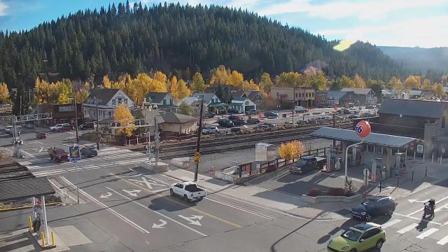 Elevation: 5850 ft Image modification time: Thu Oct 10, 2024 04:16:58 |
SR 267 junction, Truckee on I-80 @ MP 188, looking east  Elevation: 5920 ft |
Truckee Tahoe Airport, on SR 267 south of I-80 @ MP 188 Elevation: 5900 ft Image modification time: Thu Oct 10, 2024 04:16:58 |
Truckee Scales on I-80 @ MP 191, looking east  Elevation: 5800 ft |
Floriston on I-80 @ MP 199, looking SW  Elevation: 5320 ft |
| Interstate 80 Corridor in Nevada, California Border to Reno |
|||||||||||||||||||||||||||||||||||||||
Goldranch Exit 1 on I-80 @ MP 1 (Nevada)  Elevation: 5000 ft |
Goldranch Exit 2 on I-80 @ MP 2 (Nevada)  Elevation: 5000 ft |
Boomtown Garson Rd on I-80 @ MP 4 (Nevada)  Elevation: 4900 ft |
Tahoe Fire Camera on Peavine Peak, 1 mile SW of the summit, 5 miles north of I-80 @ MP 6 (Nevada), movable HD cam  Elevation: 7920 ft |
Somersett Parkway, north of I-80 @ MP 7 (Nevada) Elevation: 5300 ft |
|||||||||||||||||||||||||||||||||||