Mount Adams is the second highest peak in Washington State and the third highest in the Cascade Range. It is a
broad volcanic massif which towers above the surrounding hills about 30 miles north of the Columbia River. The
summit is covered by a large icecap, and over a dozen glaciers pour down its flanks, most via massive and
treacherous icefalls. However, the South Rib (Suksdorf Ridge) route is crevasse-free, providing one of the easier
climbing routes and nicest ski runs on any of the northern Cascade volcanoes. It has over 7000 ft (2100 m) of
skiable vertical in the spring, including a near-perfect 30-degree pitch for over 2500 ft (800 m) below the false
summit. An even better descent is the Southwest Chutes variation, which drops for over 4000 vertical feet (1200 m)
from the false summit at a consistent 35-40 degree pitch.
| Route |
Ratings |
Starting
Elevation |
Elevation
Gain |
Roundtrip
Distance |
Notes |
| Quality |
Effort |
Ascent |
Descent |
| Summit Ski Mountaineering Routes:
|
South Rib
(Suksdorf Ridge) |
 |

9.5 |
 |
 |
5600 ft
(1700 m) |
6700 ft
(2000 m) |
12 miles
(19 km) |
This non-technical summit route is one of the true Cascade classics.
The slope below the 11,657 ft false summit (Piker's Peak) holds a consistent
25-30 degree pitch for over 2500 vertical ft, often with superb corn snow in
late spring and early summer. The entire route is crevasse-free, although the
section above the false summit ascends the glaciers of the massive summit
icecap, and it is relatively easy to ascend the entire route on skis. A
downside is the extremely nasty "road" to the trailhead, often blocked by
fallen trees and snow at low elevation through late spring, and really more like
5 miles of streambed when snow-free. (See my
ski trip reports from June 1997 and July 1998.) |
Southwest Chutes
from False Summit |
|

10.0 |
|
 |
5600 ft
(1700 m) |
6700 ft
(2000 m) |
14 miles
(22 km) |
A variation of the previous route, with even better ski terrain. The chutes drop SW from
the false summit at a 35-40 degree slope for over 4000 vertical feet. Can climb either the
South Rib or the chutes directly. If done after late spring, the traverse back to the
climbing route from the bottom of the chutes may be snow-free. |
| Mazama Glacier |
 |
10.5 |
 |
|
5600 ft
(1700 m) |
6700 ft
(2000 m) |
15 miles
(24 km) |
Another (somewhat circuitous) variant of the South Rib, which avoids that route's crowds
at least below the false summit (the routes merge above). Moderately crevassed, this
route also a fine long, steep pitch as it drops SE from the false summit. |
Avalanche Glacier -
White Salmon Glacier |
 |
10.5 |
|
|
5600 ft
(1700 m) |
6700 ft
(2000 m) |
15 miles
(24 km) |
A moderate glacier route which avoids the crowds of the South Rib. The upper part
of the White Salmon Glacier is somewhat steeper and crevassed, and exposed to
rockfall from rotten cliffs nearby. However, in August 1997, a massive
debris avalanche covered the lower Avalanche Glacier in 5 million cubic meters of debris,
about 90% snow and ice. This was the largest avalanche in the Cascades since 1963
(not counting the landslide of Mt St Helens' 1980 eruption). |
North Face of
Northwest Ridge |
|

11.5 |
|

 |
4700 ft
(1400 m) |
7600 ft
(2300 m) |
16 miles
(26 km) |
This steep face falls from the Pinnacle (the NW summit of Adams) for nearly 3000 ft
of 40-50 degree terrain. The route is snow in early season, but hard neve and ice
later on, making it unpleasant and risky for skiing, although it is a decent intermediate-level
alpine ice climb. No crevasse hazard on the face, but the lower part of the route
joins the heavily-crevassed Adams Glacier. |
| North Ridge |
|
12.0 |
|
|
4600 ft
(1400 m) |
7700 ft
(2300 m) |
17 miles
(27 km) |
This is the second most popular climbing route on Adams, and the first ascent route in 1854.
Mostly moderate and easy terrain when snow-covered, although there are a couple of narrow
and exposed sections above 9000 ft. This route is a notoriously unpleasant scramble on
the descent after the snow is gone, but that shouldn't be a problem on a spring ski trip. |
Lava Glacier /
Lava Ridge |
|
12.0 |
|
|
4600 ft
(1400 m) |
7700 ft
(2300 m) |
18 miles
(29 km) |
This steep route reaches 45-degrees on the upper part of the headwall. Not sure if
anyone skis it, but in the photo on page 62 of the Cascade Alpine Guide it looks like a
fine steep skiing route. Early season and a deep snowpack would be required to avoid
hard neve (on the glacier headwall) or rocky sections (on the ridge). |
| Other Ski Mountaineering Routes:
|
Gotchen Glacier
via Aiken Lava Bed |
|

7.5 |
 |
|
3800 ft
(1150 m) |
4200+ ft
(1300+ m) |
14 miles
(22 km) |
A very gentle low elevation route which follows the massive 4-mile long lava flow
of the Aiken Lava Bed. The Gotchen Glacier is a small cirque glacier fairly low
on the SE flank near the South Butte. This route is also an alternative early season
access to the South Rib, since the Smith Butte snow park at 3800 ft is plowed out
while the road to the South Climb may be blocked by snow as low as 3000 ft. |
| Crescent Glacier |
|
6.0 |
|
|
5600 ft
(1700 m) |
3000+ ft
(900+ m) |
6 miles
(10 km) |
The Crescent Glacier is another small cirque glacier filling a basin low on the mountain.
The South Rib route goes past the western edge, so this makes a good alternative if
poor weather prevents an ascent to the summit. There are numerous short but steep
pitches around the cirque. |
|
Upcoming additions: |
Topographic map showing all ski routes. |
| Full page descriptions and photos of South Rib, SW Chutes, and North Ridge routes. |

|
Mount Adams from the NW in July, with the Adams Glacier at center
and the North Face of the NW Ridge dropping straight down
from the Pinnacle, the highest visible point
(photo by Amar Andalkar) <click to enlarge>
|
|

|
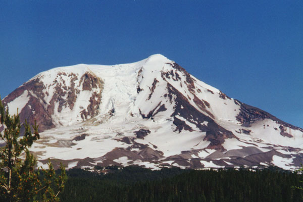
The western face of Mount Adams in July, with the three main summits of
(left to right) the Pinnacle, the true summit, and at right the false summit.
The Southwest Chutes angle down and right from the false summit.
The White Salmon glacier drops from the gap to right of the Pinnacle.
(photo by Amar Andalkar) <click to enlarge>
|
Useful Web Links:
List of Guidebooks: (detailed references on the
bibliography page)
More photos, routes, links, references, etc. coming soon...
Please contact me with any suggestions, additions, or corrections.
|